


Weekly Weather Watch: Tuesday, November 4th, 2025
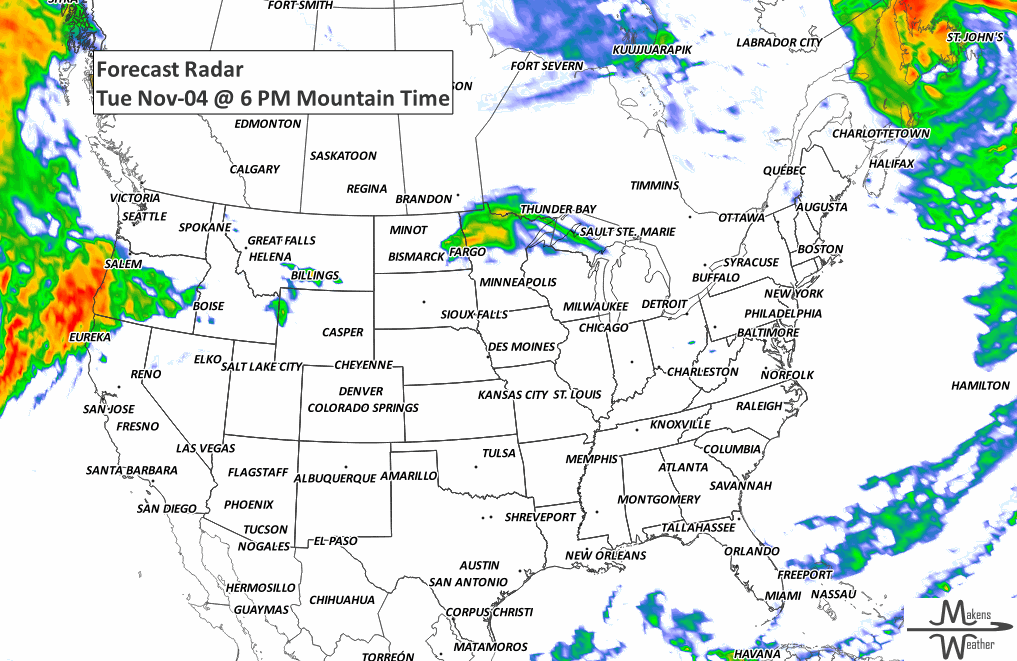
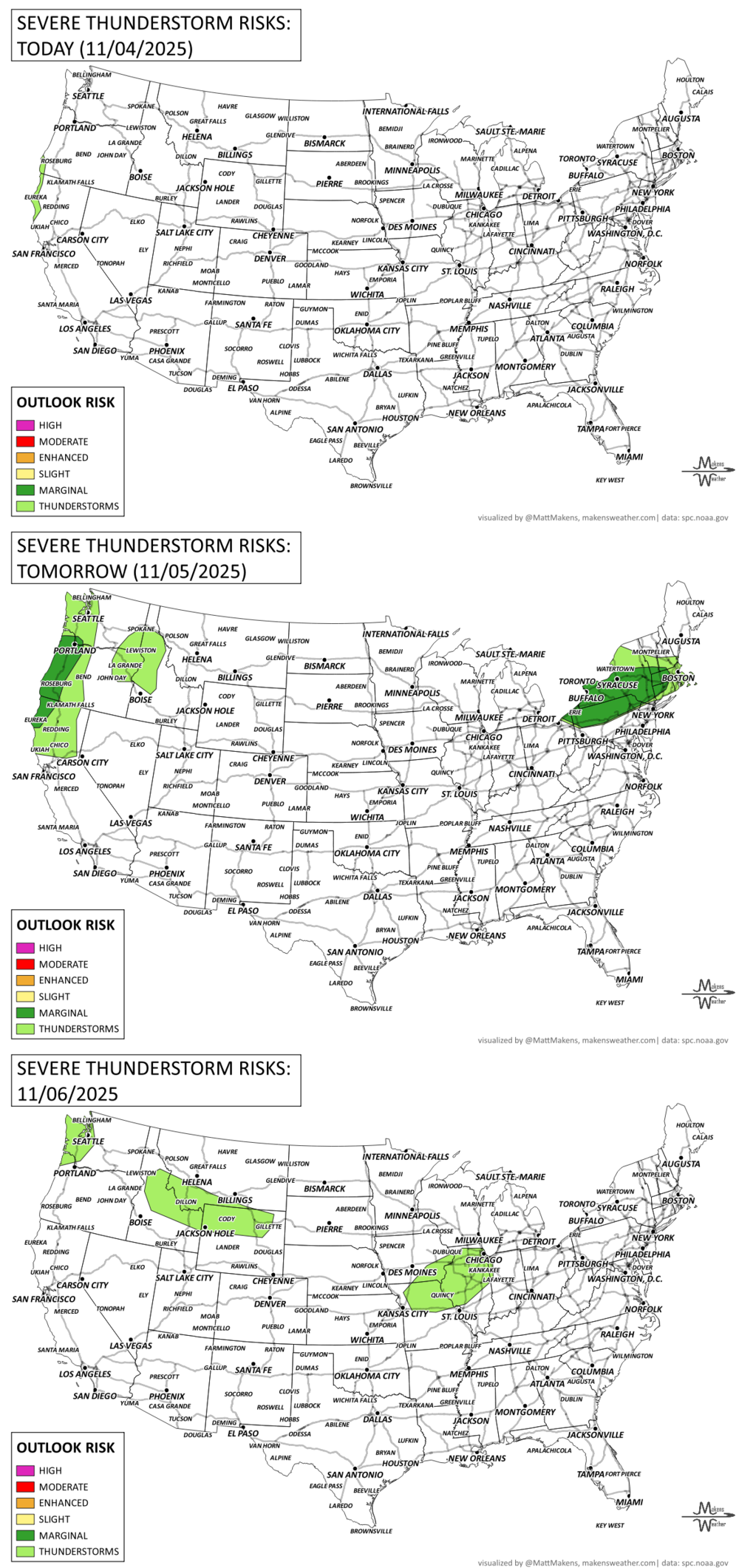
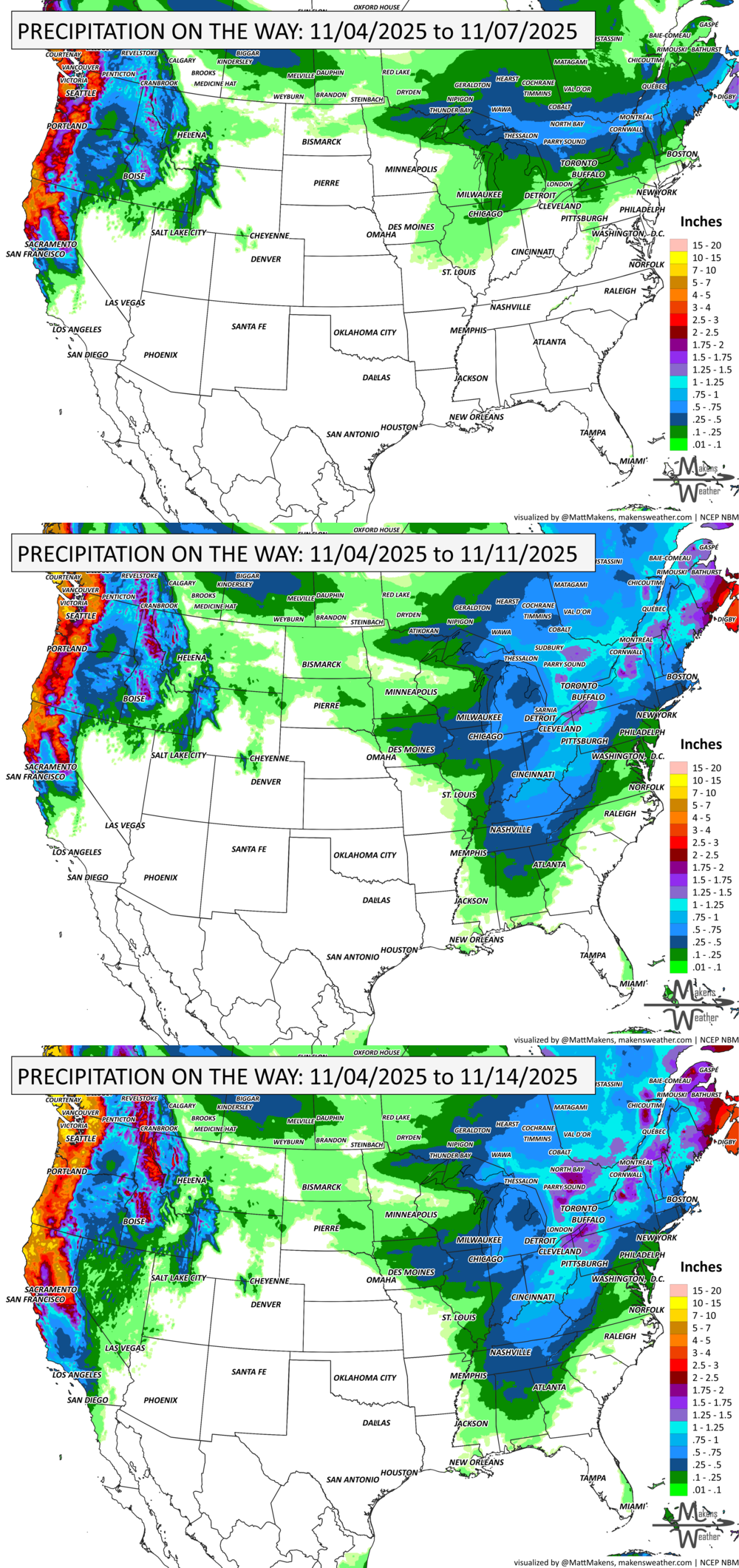
An active stretch of weather kicks off this week, especially in the Northwest and Northern California, where an atmospheric river will deliver rounds of heavy rain, gusty winds, and mountain snow through Wednesday. Meanwhile, a quick-hitting front brings some showers to the Northeast today. Heading into the weekend, a sharper shift takes shape: Arctic air surges south into the Central and Eastern U.S., bringing a chill, wintry mix, and even sub-freezing lows deep into the Plains and Tennessee Valley. Significant wind will impact British Columbia and Nova Scotia, a harder freeze expected in Saskatchewan, and areas of heavy snowfall in Alberta.
💧PRF INSURANCE
For those in agriculture, PRF insurance isn’t due until December, but I’m already processing many requests for 2026 rainfall grid outlooks. Members receive discounts on custom PRF grid analyses.
📈 The latest outlooks and conditions - track it 👉 Join Now to Access the Dashboard
HEADLINERS:
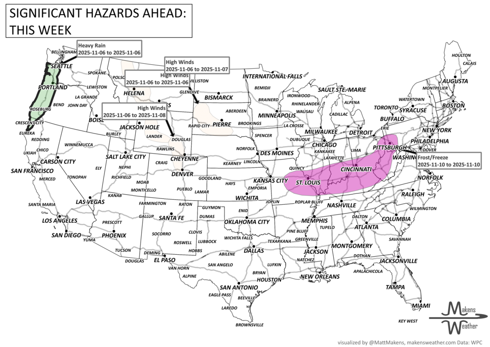
Key Weather Impacts:
Tuesday–Wednesday:
• Heavy rain and mountain snow for Northern California and the Pacific Northwest
• Gusty winds and potential flooding, especially along the coast
• Light rain and breezy winds behind a front in the Northeast
Thursday–Friday:
• Scattered showers for the Great Lakes and Northeast, possibly ending as snow in the Northern Appalachians
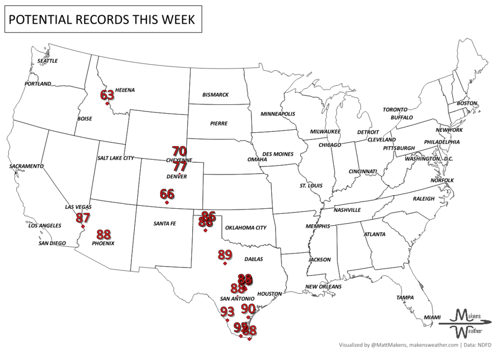
• Breezy, dry, and record-warm in parts of the High Plains and Texas Panhandle
Weekend (Saturday–Sunday):
• Arctic front pushes south, bringing colder air and a wintry mix to the Upper Midwest, Great Lakes, and New England
• Rain ahead of the front for the Ohio Valley and Interior Southeast
Early Next Week (Monday–Tuesday):
• Sub-freezing lows may reach as far south as the Tennessee Valley
• Temperatures 10–15° below normal across the East, while the West warms above average
• Another storm system brings rain back to the Pacific Northwest and Central California
ON THE RADAR:
KEEP AN EYE TO THE SKY:
IN THE GAUGES:
GRAB A RULER:
RECORDS MADE TO BE BROKEN:
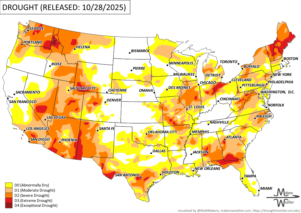
UN-DROUGHTABLY DRY:
Heavy rain last week brought much-needed moisture to parts of the West, Southern Plains, and Southeast, leading to notable drought improvement in many areas. Some locations in the Pacific Northwest, Oklahoma, Texas, Mississippi, and Florida saw more than 5 inches of rain. Meanwhile, other parts of the country—including the Northern Plains, Texas Panhandle, Deep South, and Northeast—saw drought conditions worsen slightly where rainfall missed.
Overall, drought coverage in the Lower 48 shrank a bit, with areas experiencing at least some dryness (D0 or worse) dropping from 72% to 69%. True drought (D1 or worse) declined modestly to 43.6% of the country but remains well above the long-term average. Alaska stayed drought-free, and Puerto Rico and Hawaii saw little change. -U.S. Department of Agriculture
TROPICAL TIDINGS:
The tropics are quiet at the moment.
ARE YOU CIRRUS?!
1959 A tornado in Alaska?! A small F0 tornado caused minor damage near Cape St. Elias Light Station on Kayak Island. There were no injuries.
1927 A decaying tropical cyclone dumped more than 15 inches of rain on the Green Mountains of Vermont. The flooding killed 200 people.
A drawn-out storm pattern will keep much of the country active through the first week of April. A slow-moving front stretching from the Great Lakes into the Plains will separate late-season snow and ice to the north from heavy rain and severe thunderstorms to the south. The setup brings the greatest impacts to parts of the Midwest, Ohio Valley, Southern Plains, Mississippi Valley, and eventually the East Coast, while the West sees mountain snow and then a warming trend heading into the weekend.